Linville Falls
The Blue Ridge Parkway's Biggest Waterfall
FIND THE TRAILHEAD
Start the hikes to Linville Falls from a small visitor center and parking area 1.5 miles from the Parkway, past the Linville Falls Campground. To reach the spur road, leave the Blue Ridge Parkway at Milepost 316.4, about 1 mile north of the US 221/Blue Ridge Parkway junction in the town of Linville Falls, or about 11 miles south of the US 221-Blue Ridge Parkway junction at Grandfather Mountain near Linville.
View and download a map of the trails
TAKE THE HIKES
View Linville Falls from Above
From the visitor center (restrooms from May through October), bear right across the bridge to reach the easiest views of this awesome waterfall, the Parkway's largest by volume of water.
The level, road-width Linville Falls Trail leads through a scenic forest along the river to a junction on the right at 0.4 miles. In another 0.1 mile, turn left to Upper Falls View where the river funnels over its first big drop.
Turn back to the main trail, and go left on the easy path through towering trees. The trail climbs into scrubbier vegetation to craggy overlooks above the gorge. At 0.6 miles from the visitor center, go left at a rain shelter down steep steps 0.1 miles to the airy perch of Chimney View for another great falls vista.
Back at the shelter, go left and not far on the right is Gorge View. Peer down into the gorge. At about 1.0 miles from the visitor center, Erwins View overlooks the falls, gorge, and hikers back on Chimney View. Return for a 2.0-mile round-trip hike.
Linville Falls from Below
To really get a feel for the power of the falls, many choose to trek down the steep trail to the base of Linville Falls. Back at the visitor center, pass through the visitor center portico and take the Linville Gorge Trail to the right. At a junction in 0.5 miles, turn right and go down steeply but briefly to Plunge Basin Overlook, a rock-walled perch above the falls. It's a 1-mile round-trip back at the visitor center.
Back at the Plunge Basin View junction, take the Linville Gorge Trail right along handrails above steep drops and down a steep flight of steps. At the bottom of the steps-the trail turns abruptly right-don't keep straight. The trail descends below a towering cliff to the edge of the river where you can rock-hop near the base of the thundering falls (ice may interfere in winter). To the base of the falls and back is 1.4 miles round-trip. Include the side trip to Plunge Basin Overlook, and it will be about 1.8 miles.
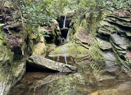
Duggers Creek Falls
Don't miss Duggers Creek Falls, a tiny but beautiful waterfall on the back side of the Linville Falls visitor center's parking area. The trail starts at the visitor center and meanders around the far end of the long parking lot via a 0.2-mile trail. The waterfall itself can be seen from a bridge along the path.
Help preserve these incredible trails by planning ahead, keeping on designated trails, respecting wildlife, packing out any trash, and being considerate of others out in nature. Practice waterfall safety by staying out of the water above and beneath the falls, never climbing on slippery rocks, and keeping a close eye on children.
Click through the images below to learn more about how to help Preserve the Awe of the Blue Ridge Parkway's natural wonders!


