drift along one of north america's oldest rivers

This graceful river flows northward and is one of the few rivers in the country to do so. The quiet stream gets its start in the mountains near Blowing Rock, then meanders through the Blue Ridge Mountains before exiting the state near Todd. Its gentle current and dazzling scenery along the South Fork of the New River make this trail perfect for those just beginning to paddle. Whether you're keen to kayak, committed to the canoe, or tempted to tube*, the Boone Area section of the New River is a relaxing, scenic paradise.

As with any river, the flow of water throughout the year does change. There are many factors that lead to these changes: rainfall, drought, downed trees, dam releases, or flooding, just to name a few. On average, the South Fork New River has a water level of 2.5', but may vary between 2' and 8'. Low levels may make the length of time on the water longer, as more paddling is needed to reach your destination. Higher water levels may result in faster current, flooding, energetic waters (rapids, riffles, etc.), and possible increased hazards (strainers, debris, downed trees). Launching and landing areas may be more difficult to navigate as your access points may be altered. If you are unsure of current water levels, our local outfitters would be happy to answer any questions you may have.

A large map of the New River paddle trail (shown below) is posted at the Pine Run access, providing distances between points and estimated float times for kayaks and tubes*. We encourage you to customize your trip and consider the water levels during your visit, along with the skill level of those who may be joining you. For a pocket map of the Paddle Trail, give us a call or visit our office as cell service may be sparse in some areas. 

*Tubing is not recommended for the trail section between the Boone Access to the Castle Ford Access.

NR Paddle Trail Map - Optimized

Some of these access points have limited parking areas. Please do not park at an access that is already full, and ensure all four of your vehicle's wheels are off the road. Never park on private property.


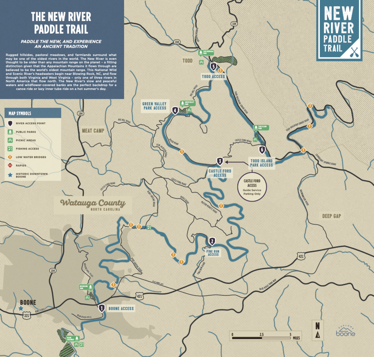
Parks Along the Trail


Green Valley Park at the Green Valley Access

Green Valley Community Park is a multi-purpose park on the banks of the New River offering a picnic shelter, playground equipment, multi-purpose playing fields, hiking trails, and a canoe ramp.

Todd Island Park at the Todd Island Park Access

This unique, 5-acre park is an island in the middle of the South Fork New River, about 3 miles downstream from Todd's Rural Historic District. The park is open from dawn to dusk and features a short walking trail that wraps around the perimeter of the island. The trail also provides access to the south channel for easy fishing.

Cook Memorial Park at the Todd Access

Cook Park in historic Todd is a perfect spot for picnics, fishing, or just relaxing by the water. It also hosts the Todd Summer Concert Series and is home to the Todd New River Festival. 


Need a ride or gear?

Check out these Local Outfitters